

Parametric data
- Route name:
- Morden (Phipps Bridge Tram stop) to Merstham.
- This route on OS maps:
- https://explore.osmaps.com/route/14611254/... .
- Distance:
- 12.5 miles.
- Ascent:
- 247 metres.
-
Duration
-
5.3 hours. - Topology:
- Point to point (southward).
- Ascent:
- 300 metres (it's over The Downs).
- Stiles:
- 0 (zero). This is not a country walk.
- Landmark of note:
- The 'Hog Pit' at Carshalton Park. It's vast, but nobody really knows why it is there.
- Feasible excursion:
- Oaks Park. Better surface and, probably, more to see. Longer.
- Avoiding roads:
-
 This looses a 'nana on account of having to cross the
A23 at the M23 slip at Merstham. A scandal in my view
but, at least, you don't have to walk along any road
beyond a short, private drive at Carshalton and the
upper stretch of Rickman Hill.
This looses a 'nana on account of having to cross the
A23 at the M23 slip at Merstham. A scandal in my view
but, at least, you don't have to walk along any road
beyond a short, private drive at Carshalton and the
upper stretch of Rickman Hill.
- Footpath construction:
-
 As a predominantly suburban walk, this ought to have
scored better, perhaps. True, there are long stretches
of BLA or tarmac but Woodmansterne Road and the
following
track
down to Grove Lane let it down.
As a predominantly suburban walk, this ought to have
scored better, perhaps. True, there are long stretches
of BLA or tarmac but Woodmansterne Road and the
following
track
down to Grove Lane let it down.
- Footpath condition:
-
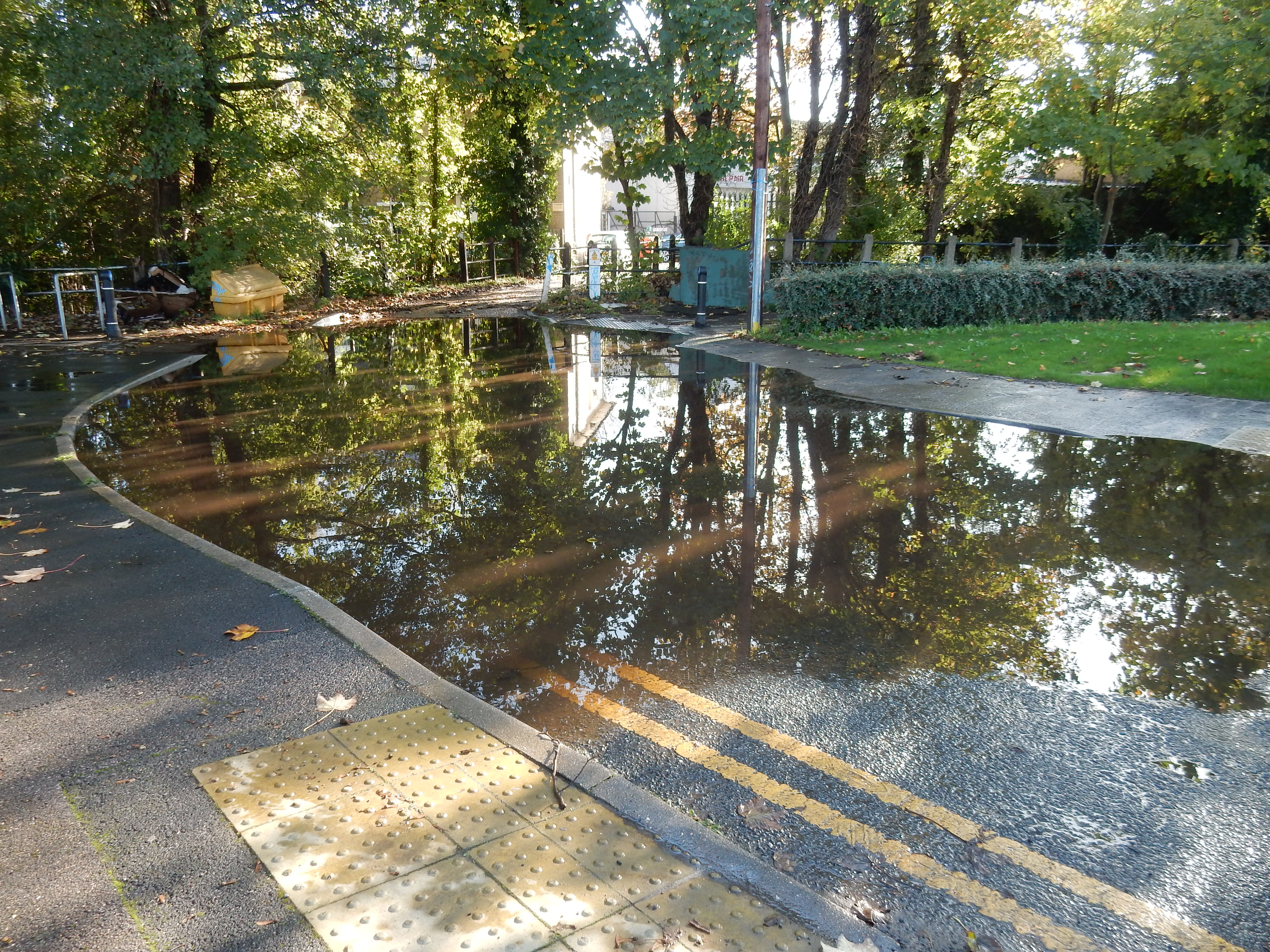
 In November expect to see the wet leaf on any walk, and
a few of its mates, too.
This, though, is not the River Wandle itself but the
Wandle Trail
path, 24 hours after it stopped raining. I chose
the wrong time of year, didn't I?
In November expect to see the wet leaf on any walk, and
a few of its mates, too.
This, though, is not the River Wandle itself but the
Wandle Trail
path, 24 hours after it stopped raining. I chose
the wrong time of year, didn't I?
- Refreshments:
- Sandwich from Londis Coulsdon. Consume at Rickman Hill.
- Vistas:
-
 Disappointing for a crossing of the Downs. Prospect
Plantation doesn't quite live up to the name.
Disappointing for a crossing of the Downs. Prospect
Plantation doesn't quite live up to the name.
- Blackberries:
-
Along the Wandle Trail or the LOOP should be good in season.
Route map.
Walk notes.
The tram from East Croydon is the first I have taken in a westerly direction. Its lurch through the town centre does my breakfast no favours. Again, the prudent give thanks for the transport actually available to them in the era of the two-day stoppage.
I might have explored Morden Hall further, but the hour hand moves faster than my legs so I press on down to the Wandle Trail, forming part of The National Cycle Network Route 20. This latter continues southward to my home territory, where I know it not to be a guarantee of a firm, dry surface. Furthermore, this section follows the river valley eastwards in the direction of Mitcham; so an occasional puddle was anticipated. We live and learn so, maybe, in summer 2023 I will plan another walk - from Wandsworth to Croydon, perhaps.
You have not gone 70 yards along the trail before a rather singular landmark appears. This reminder of the Wandle's working history is from one of several mills that it supported until the ¢20. You have already reached the second of several 'Victorian legacy' parklands offered on this walk: Ravensbury Park. How, I wonder, can any crinoline-clad female of the time have negotiated terrain of this nature? Perhaps other people did the laundry.
Next up, Mitcham Bridge carrying the A217 across the Wandle. Although I negotiated that highway almost every day during my working career, I had no inkling of its significance to the current walk. My ignorance extended also to the ensuing Watermeads - another gift of the Victorians: Octavia Hill, no less. Through Poulter Park and Watermead Lane to reach the next bridge at Goat Road. Google Maps tautologizes the stretch to the south of this as 'Wandle Valley Wetland'. Watercress Park seems the better term.
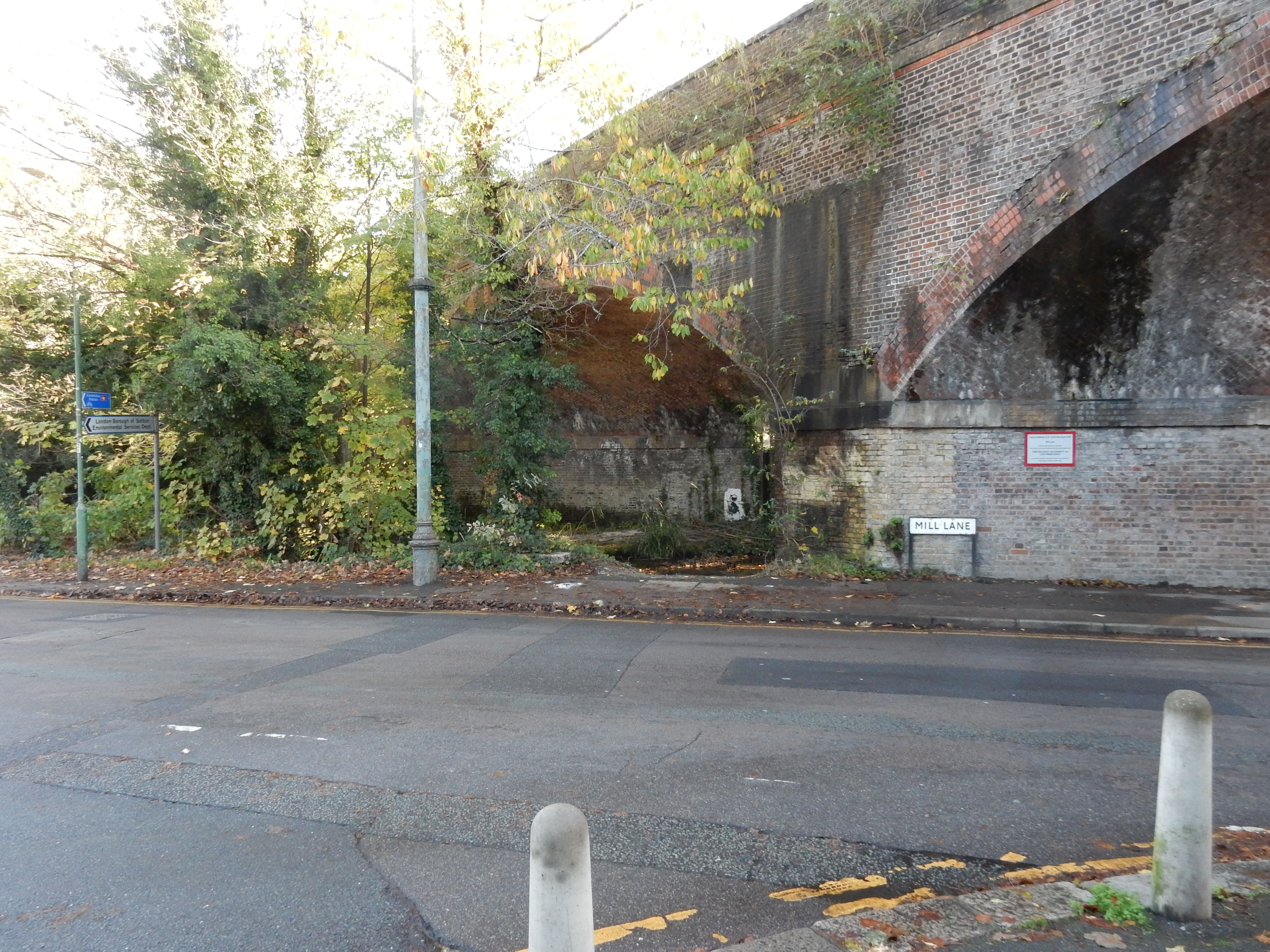
Further revelation awaits me at the B277. I became aware of a place named Hackbridge during my youth when driven by my father to see his father in Norbury, but who knew that the specific bridge from which the name derives spans the Wandle here? Time is not so short that a minute or two cannot be spent here admiring the Hackbridge Community Garden. The Wandle upstream of this bridge is divided into a course flowing to the west of Wilderness Island and one flowing to the east. It was here that a branch of the Surrey Iron Railway from Mitcham terminated. The main line of this haulage system terminated at my final destination. After the SIR became obsolete in 1846, sections of the route were re-used for its steam-powered successors. Those sections were re-used again for the Tramlink, which brought me to the start of the walk. The route may be similar, but the charge of £1.50 for using it is more up to date. The weiry[hum], Merstham bound traveller selects the western course, and is soon passing underneath the Sutton and Mole Valley rail line in Mill Lane. This takes him to Papermill Close (road names adhere to a theme) marking the start of the 'short' (9-mile) version of the Wandle Trail toward Wandsworth.
On the left now is The Grove at Carshalton; a popular amenity for local residents. You can't escape Victorian values or mills on this walk. We're not done with either yet. Here comes Carshalton Park being readied for a bonfire night display. I toy with the idea of strapping my tired old iPhone, and its knackered battery onto one of their rockets. It never was up to more than two or three hours of GPS, so I have to do the rest of the walk from memory. I've brought only OS sheet 161 with me 🤔

The next bit of parkland has partially fallen to the property developer. Its fate was sealed by belonging to an old style NHS hospital adjacent to existing suburbia: Queen Mary's Hospital for Children. Why waste all that space on patients, such as this boy attending for surgery on his ear in 1964. A hospital motivated to make those in its care feel better? It's doomed. Well, the route shown here goes along Monkey Puzzle Way, at the end of which is this item of Victoriana.
More trees next. I was underneath them for the whole of the stretch along Woodmansterne Road. I thought at first that someone or other had gone to some trouble here with a leaf blower. No, the rain on the previous day created a torrent down the path sufficient to wash leaves away. So, the sensible alternative would have been to follow Cycle Route 20 through Oaks Park. Next time, maybe.
A dash for dear life across the ridiculously busy A2022 takes you down the footpath forming part of the 'LOOP'. Like its motor vehicular counterpart, the South Circular Road, the LOOP is largely an idea in the mind of a planner. Absolutely any old bit of dirt qualifies as suitable for it. This section, leading down to Grove Lane in Coulsdon is by no means the worst and, on the day, was not in the least overgrown. There's even a final reminder of what the Victorians did for us. After the LOOP you have tarmac for the remainder of the walk.
The trek through Coulsdon down to the A23 is not worth a kilobyte of web space to describe. The bit of lunch bought in Chipstead Valley Road provided the calories needed to get me over the last half of the walk. Don't spend too much time at Hooley trying to find a proper footway right along the A23. There isn't one. On reaching the High Street in Merstham, you can check out the preserved section of 'rails' from the SIR, and now better appreciate what this technology of old achieved in its day.