

Parametric data
- Route name:
- MertonPark
- Start point:
- Merton Park
- End point:
- Blackfriars.
- This route on OS maps:
- https://explore.osmaps.com/route/15026114/... .
- OS Explorer sheet ref(s):
- 161 and 173.
- Distance:
- 9.5 miles.[1]
-
Duration
-
4.4 hours. - Topology:
- Point to point (north-eastward).
- Ascent:
- 64 metres.
- Stiles:
- 0 (zero). Nor any notice ordering you to KEEP TO THE FOOTPATH.
- Landmark of note:
- Memorial to the Clapham Rail Crash off Spencer Park.
- Feasible excursion:
- Future walks of this route will not see me take the Ordnance's diversion in Queenstown Road.
- Avoiding roads:
-
 (assuming you ignore the OS).
- Footpath construction:
-
Tarmac, and nothing but. It's why I'm not in Sussex.
- Footpath condition:
-
 Some gritting done, but no avoiding slushy bits.
- Refreshments:
- All-day brekka from Bridge the Gap, in Battersea. Nice place and (super important) warm.
- Vistas:
-
 It's the Thames Valley. What were you expecting? You do
go right past the
London Eye.
It's the Thames Valley. What were you expecting? You do
go right past the
London Eye.
- Blackberries:
-
 Not even at the cafe.
Route map.
Walk notes.
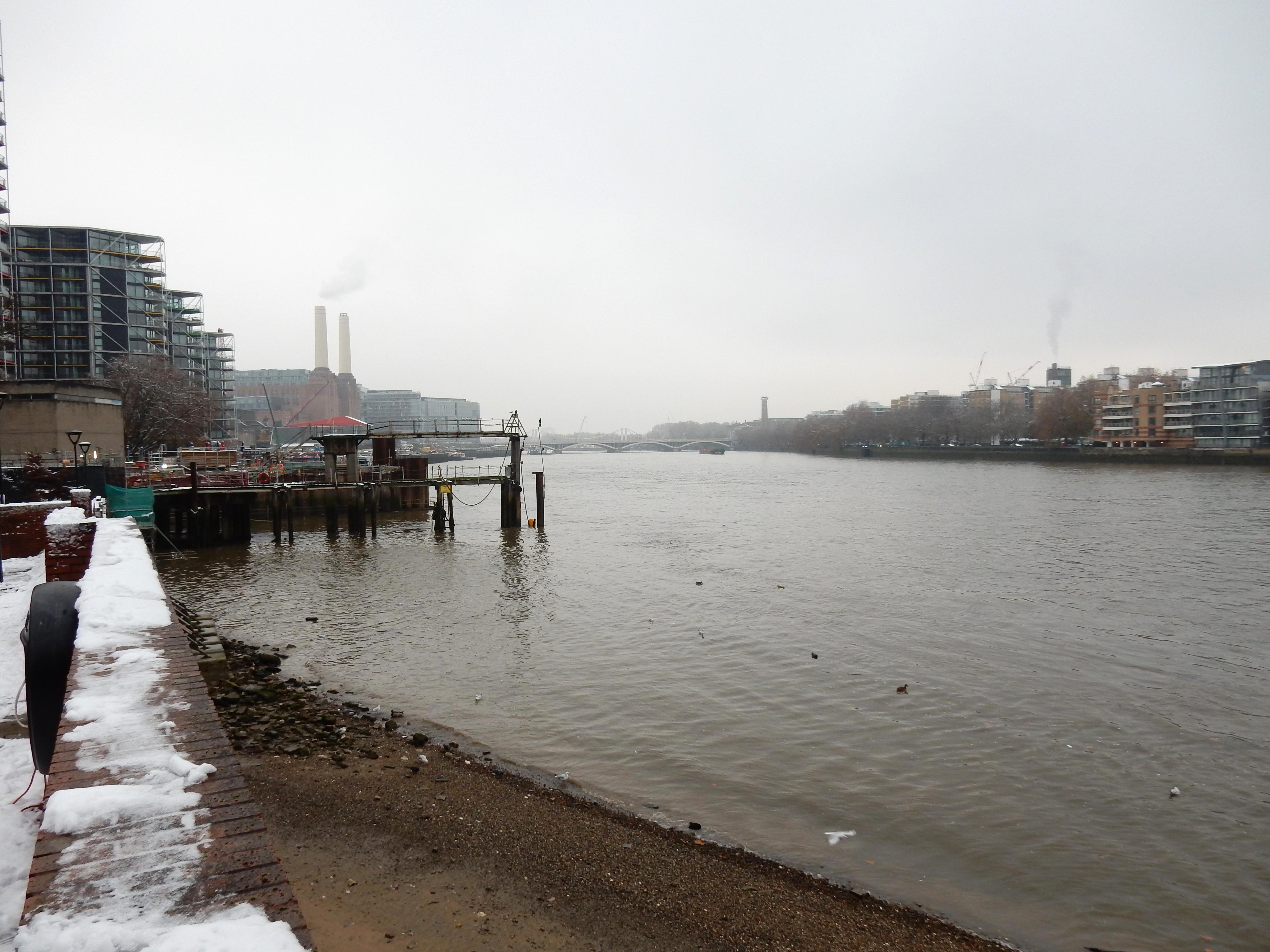
Today's travellers are rewarded with views of Chelsea and Albert Bridges to the west and Nine Elms and Battersea Power Station to the east.
The Battersea Society.
Too late, I realise that GPS cannot be relied on for the whole walk. By way of a Plan B, I compile, by hand, a turn-by-turn itinerary, as I had done on my Croydon walk. It seems to work around town, if not countryside. With time to write only about half the list, Plan C is a six-page print of the OS route map. This saves the day, but imagine the pain stopping 46 times somewhere clean and dry to fish out the folder, turn to the right page (using frozen fingers), find the point I have reached, memorise the next leg, and then return it all to the backpack. Life is too short.
Failure to plan, they say, is planning to fail. So it goes with my tram journey. The notion enters my head that Morden Road is the stop I want, and I alight half a mile before Merton Park. Sorting this puzzle out delivers the coup de grâce to my battery. Fine. I pick up the original route in Trinity Road, but hopes of completing the walk in daylight dwindle further.
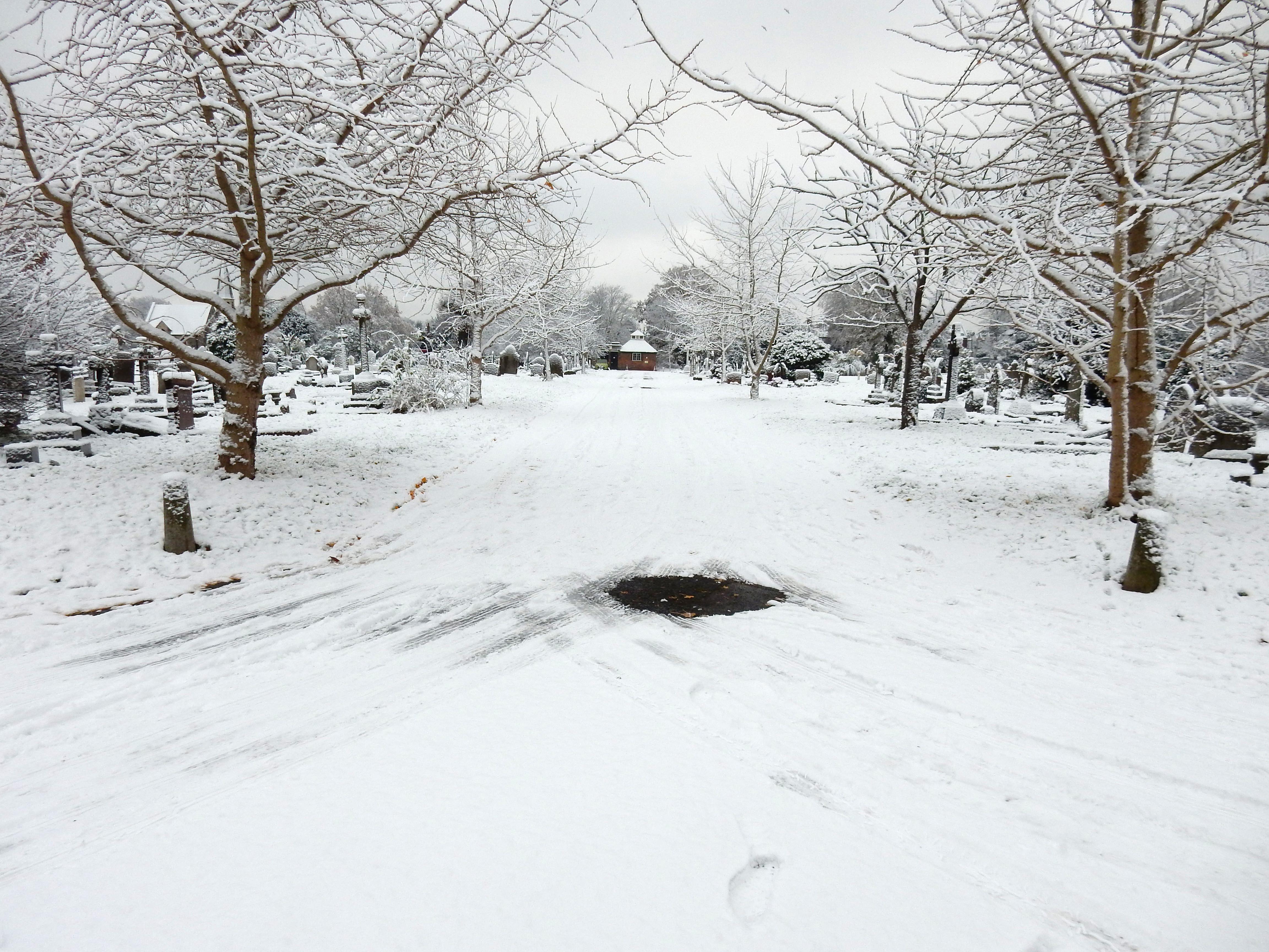
The best snow scene of the walk is at Gap Road Cemetery where the cold has lasted a little longer (in the imagination, anyway). Confidence in the navigation thus far proves unfounded, and I sail down Durnsford Road, reaching Arthur Road before realising I have overshot Endeavour Way. Another ten minutes blown 😖
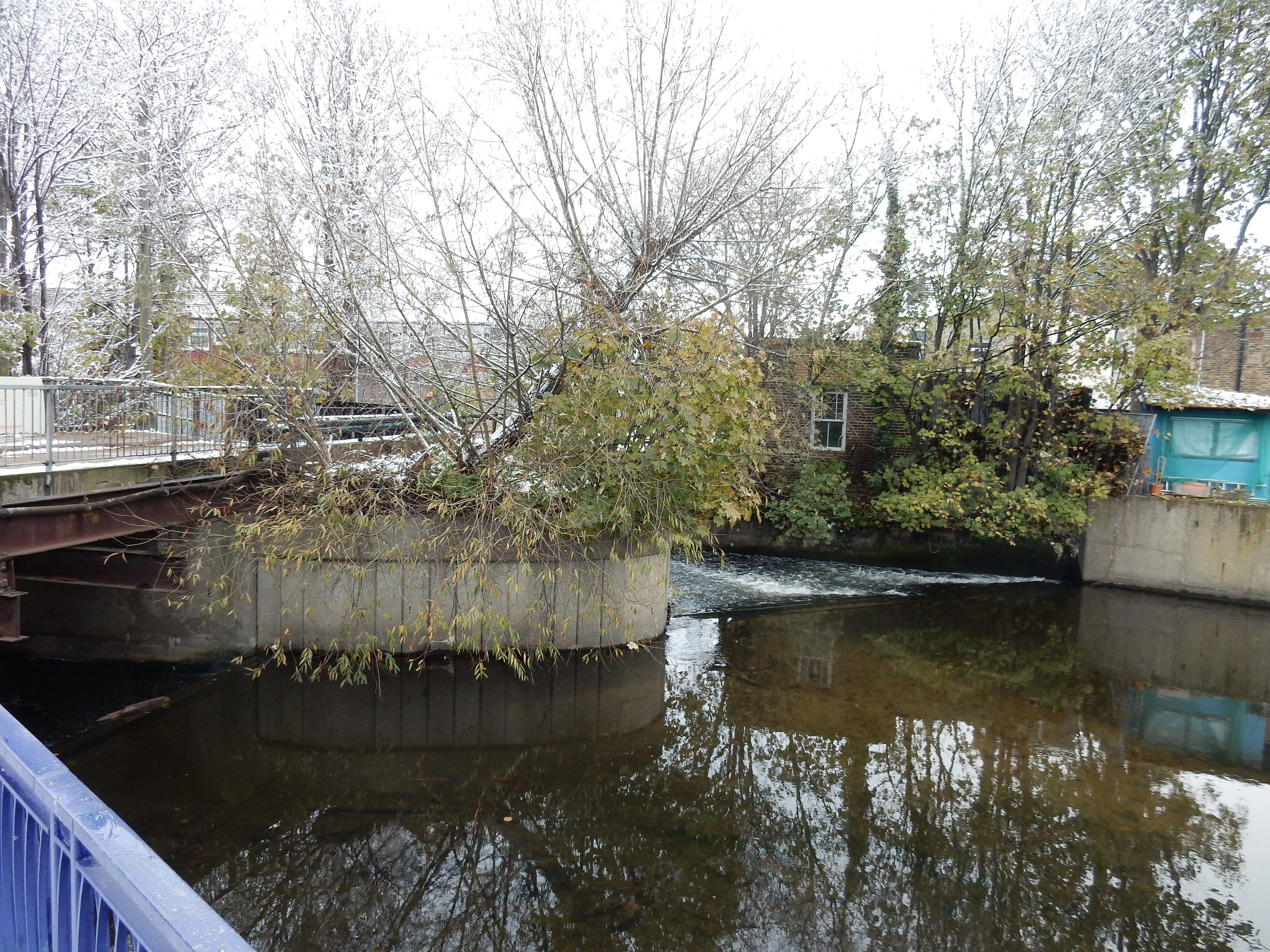
Leaving the unlovely Weir Road brings into view (surprise!) a weir on the Wandle. This, naturally, marks a low point of the walk at 9 metres ASL. Five weeks earlier I walked the Wandle Trail from almost the same start but in the opposite direction. The problem then was flooding due to rainfall the previous day. What luck! No rain yesterday. Dohh.
Earlsfield Road climbs gently up from the Wandle valley for nearly a mile, and progress on still unfatigued legs is the best of the walk. Were I not in a hurry then I would notice that the road has morphed into Windmill Road before it crosses Trinity Road (that signage states is A214). Five minutes sorting this out on paper. Next up: Emmanuel School where my father was educated in the 1930s. All I ever heard about his time there was that he enjoyed the rowing.
Not far along from upmarket education is the A3036 and Lavender Hill. Dad felt nostalgic towards Clapham Junction, claiming he travelled from there to anywhere by train. I am lucky any trains run today. Eversleigh Road is another plod along the side of the tracks. Again, I get caught out as it morphs into Broughton Road. On my walk from Victoria to Croydon the OS came up with the same ¼ mile detour off Queenstown Road as it does today. Why? Does it imagine that the tower blocks round Strasburg Road are must-see landmarks of the Capital? Does it want to test my GPS Underneath the Arches? Positively the last time I humour it.
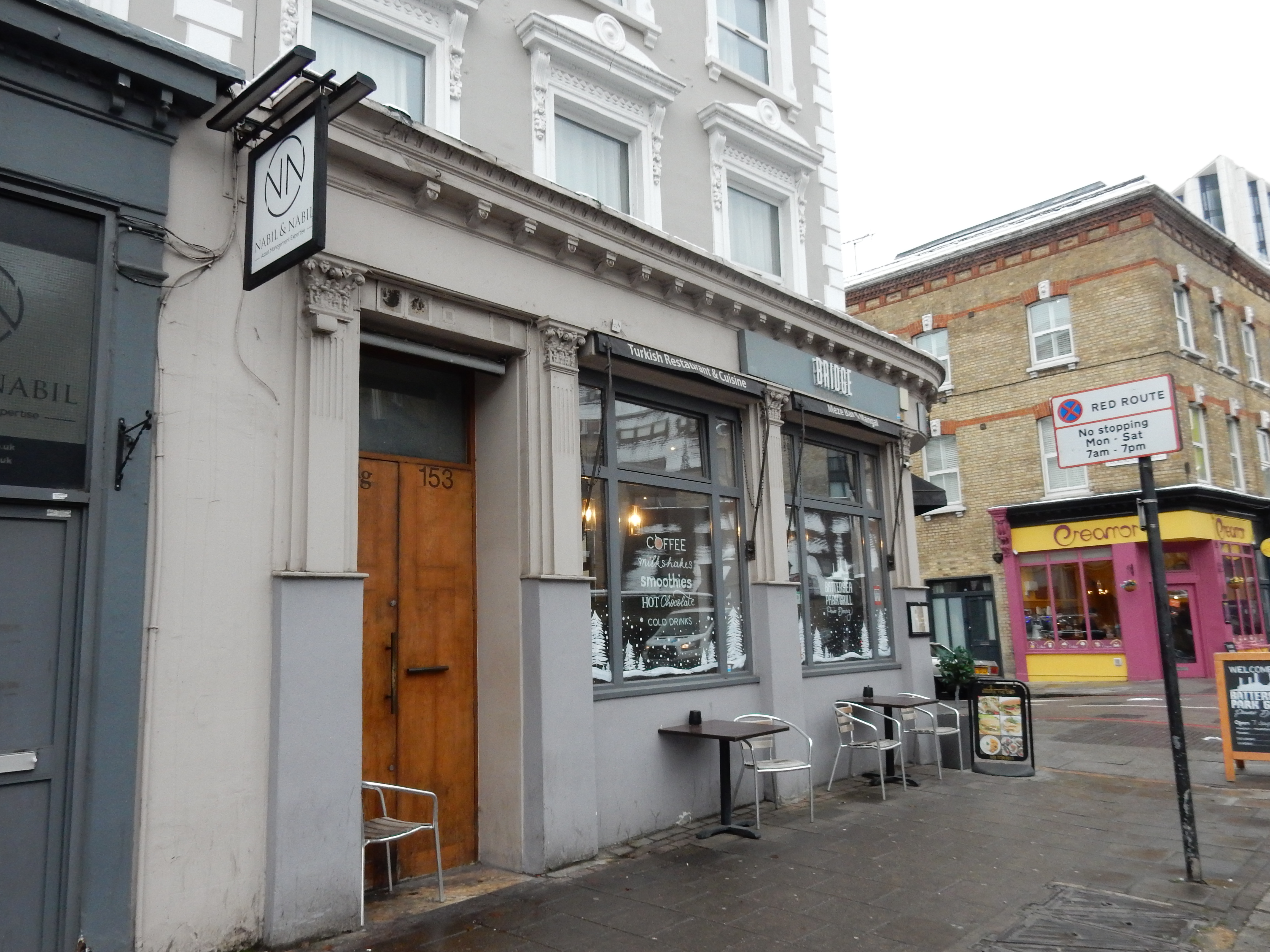
However you reach Battersea Park Road, from here onwards the walk seems to shift from suburban safari to central London proper. For first example, you are spoilt for places to eat. Eagerly, I dive into Bridge the Gap, where my fingers slowly unfreeze. Never mind what food is on offer. I need to know what room temperatures are on the menu. During my middle years, undernourishment never much afflicted me, so I enjoyed a considerable amount of, err, natural thermal insulation. After taking up walking, that all disappeared and I am now a mobile block of ice. Every silver lining has a cloud. Second example is the forest of cranes last week seen at Kings Cross, and now around Battersea Power Station. Until a couple of years ago, I could have stood in for a forty foot inflatable pig 🐖. No longer.
Opposite the Power Station is Stewart's Road where dad worked until 1969 for a small supplier of scientific equipment: Glass Developments Ltd. It had been set up in 1944 when many were convinced that British technical expertise (and contracts from the War Department) could accomplish anything. By the end, alas, it was clear that leading edge technology product research and development was a game only for multi-national corporations with the deepest pockets. It seems incredible now that he managed to commute here from Redhill in his beloved Mini; a feat all but impossible using today's congested A23.
At present my sole criticism of eateries along the A3205 is that not all feature statuesque publicity of this calibre. Surely how Hannibal would have crossed Nine Elms during winter. Until more cranes finish their work, you must pass this and the next sign for the Thames Path (which lies) before attempting to turn for the latter.
Back on the navigational issues, everything should now be plain sailing along the South Bank. For the present, anyway, agent 007 stops you, requiring a short detour down Vauxhall Bridge Road. That's easy enough but Vauxhall isn't the bridge that gives me trouble. Hungerford is because I'm on the lookout for a double bridge where the eastern part carries rail. I ascribe this brain failure to a complete lack of anti-freeze in its circulatory system.
Perhaps the signs were hidden behind a swarm of tourists. Do they, too, come in December for an exercise walk? Maybe they expect to poke fun at Ebenezer Scrooge? I might tell him to put more coal on the fire myself. All is not lost. After a bit of head scratching, my faux-pas becomes apparent and I complete my walk with a stroll down The Strand.
- -Begin walkat Merton Pk tram stop
- Aft. 70 m1st. R.into Kingston Rd.
- Aft. 87 m1st. L.into Gladstone Rd.
- Aft. 245 m1st. R.into Pelham Rd.
- Aft. 77 m1st. L.into Russell Rd.
- Aft. 300 mX The Broadwayinto King's Rd.
- Aft. 600 mTJ L.into Trinity Rd.
- Aft. 106 mX Queen's Rd.into Ashcombe Rd.
- Aft. 330 m2nd. R.into Haydon Pk. Rd.
- Aft. 230 m1st. L.into Avondale Rd.
- Aft. 120 mTJ R.into Gap Rd.
- Aft. 29 m1st. L.into Cemetery
- Aft. 340 mTJ R.into Pitt Crs.
- Aft. 130 mTJ L.into Durnsford Rd.
- Aft. 30 m1st. R.into Endeavour Way.
- Aft. 330 mTJ L.into Weir Rd.
- Aft. 520 m
(bef. 'Richmonds')TRinto FP - Aft. 170 mTJ R.into Trewint St.
- Aft. 63 m1st. L.into Summerley St.
- Aft. 300 mTJ L.into Garratt Ln.
- Aft. 180 m2nd. R.into Earlsfield Rd.
- Aft. 1300 mX Heathfield Rd.into Windmill Rd.
- Aft. 840 mX Battersea Riseinto Strathblaine Rd.
- Aft. 310 mTJ L.into Strath Trc.
- Aft. 20 m1st. R.into St John's Hl.
- Aft. 450 m
(jct. with St John's Rd.)cont.into Lavender Hl. - Aft. 320 m3rd. L.into Dorothy Rd.
- Aft. 260 mcont.into Amies St.
- Aft. 120 mX Latchmere Rd.into Sabine Rd.
- Aft. 50 m1st. L.into Eversleigh Rd.
- Aft. 850 mcont.into Broughton Rd.
- Aft. 310 m1st. L.into Queenstown Rd.
- Aft. 190 m1st. L.into Ravenet St.
- Aft. 96 m1st. R.into FP.
- Aft. 70 mcont.into Newtown St.
- Aft. 45 m1st R.into Strasburg Rd.
- Aft. 50 mbear R.into FP
- Aft. 80 mTJ L.into Queenstown Rd.
- Aft. 20 m1st. R.into FP
- Aft. 170 mTJ L.into Lockington Rd.
- Aft. 40 mTJ R.into Battersea Pk. Rd.
- Aft. 1,100 m
(opp. 'Waitrose')LTinto Riverside Walk. - Aft. 920 mTJ R.into Vauxhall Br. Rd.
- Aft. 100 m1st. L.into Albert Embankment
- Aft. 3,350 mLTinto Blackfriars Rail Br.
- Aft. 0 mend walk-