

Parametric data
- Route name:
- Otford
- Start point:
- Otford, Kent.
- End point:
- Oxted, Surrey.
- This route on OS maps:
- https://explore.osmaps.com/route/18602810/ ...
- Distance:
- 13.6 miles walked, 9.6 miles flown.[1]
- Duration
: - 6.2 hours.[2]
- Ascent:
- 444 metres.
- Stiles:
- 0 (zero).
- Landmark of note:
- Coccolith.
- Feasible excursion:
- Stay on Pitchfont Lane until Water Lane and go under the M25 using that.
- Waypoints:
- Twitton, Chevening, Knockholt, Westerham, Tatsfield, Limpsfield.
- Refreshments:
- Coffee at Otford station. Sandwich lunch above Chevening.
Weather:-
 18°C, 🌤️.
[3]
18°C, 🌤️.
[3]
-
Avoiding roads: -
 B2211[4]
-
Footpath construction: -
 Nearly all dirt.[5]
-
Footpath condition: -
 Mostly v. good but the descents exhibit deterioration.
[6]
Mostly v. good but the descents exhibit deterioration.
[6]
-
Vistas: -
Past Clarks Lane Farm.[7]
Blackberries:-
About a mile of tempting hedgerow.[8]
Route map.
Walk notes.
The follower of these perambulations will know that they are selected according to the weather. Good underfoot = countryside. Soggy = town. Well here I am in Otford at the start of almost thirteen miles of chalk downland; largely following the North Downs Way (NDW). As it turned out, this call was correct, but threats of meteorological origin about summer having been 'cancelled' are fresh in the mind, and I'm unsure how much longer I can continue across country this year.[9] Last week's stroll over Box Hill followed part of the NDW also and was very pleasant. I now resolve to add sections of the NDW until I have covered Farnham to Dover. It will be west to east, most like, because that gives more sun against my back than the other way (which goes in my eyes). Today, I choose the wrong direction but, with luck, this error will not be engraved on my tombstone. For the most part, the NDW is sufficiently well marked that you need not keep a close eye on the GPS.
It's been said that if Kent is the Garden of England then Surrey is the patio. The joy of this leg of the NDW is that it has a bit of everything in terms of scenery. You get Kent, Surrey, hillside, level ground, woodland, open field, grazing, arable, blackberry, mushroom, spitfire, partridge, parkland, car park, artwork, village high street, suburb, palace, three-up-three-down, bridge, stream, country lane, highway, byway and M25. OK, scrub the magic roundabout from the itinerary ... if you can. Although it has a railway station, Otford is the first of my walks reachable by three changes of train. It's not an early start to a six hour walk.
I confess never previously to have heard of Otford. It is modest in size. However, it has a long history, and its 'chocolate box' vernacular is worth a look. Otford claims the highest possible accolade in the form of its Roundabout of the Year awarded duck pond. Stand agog at the majesty of this circulatory wonder. Pause at one of the bridges over the River Darent.
... then people long to go on pilgrimages, and especially they wend their way to Canterbury from every shire of England ...
(After) Geoffrey Chaucer.
The OS route planner is normally good at avoiding walks in the road but, today, it insists on continuing along the B2211 until Turvin's Farm. An earlier turn, or even Star Hill Road, would have done better, and led away from the M25 sooner. The route taken includes no better scenery: a failed crop of maize. There was, however, an interesting type of gate that I have not encountered before. The dog walkers probably like it. Well, however you approach it, the steepest part of the walk goes up Star Hill, and the next few miles will add 130 metres to your altitude. This climb, and the excitement engendered by novelty metalwork, force a stop for luncheon whilst taking in the fine view from the seat at the top. There's shortly a glimpse to be had of Chevening. I do not pause to be nominated for residence there. Far too close to the M25 for my taste. The iron railings round the edge of this field testify to past opulence. Ditto specimen trees behind. A boundary of Chevening, or something else? Over a mile further on, and nearing Knockholt, you're still not done with Chevening. The disused north entrance has been left as an architectural embarrassment. Did ministerial cortège ever sweep through this portal? You doubt it.
Several of the arable fields along downland slopes are an unsettling reminder that they have exhausted their topsoil, and are now practically bare chalk and flint. They likely got along for centuries as sheep pasture but, as the trend toward cereals took off, loam washed downhill. Plowing for winter wheat starts around now, and crop roots that might hold soil in place during the months of high rainfall are not fully established until late spring 😢
As I cross Sundridge Lane I see the plow going in the next field, but it struggles over ground that has received minimal rain for weeks. This farming business is hard going. Great walking weather, though.

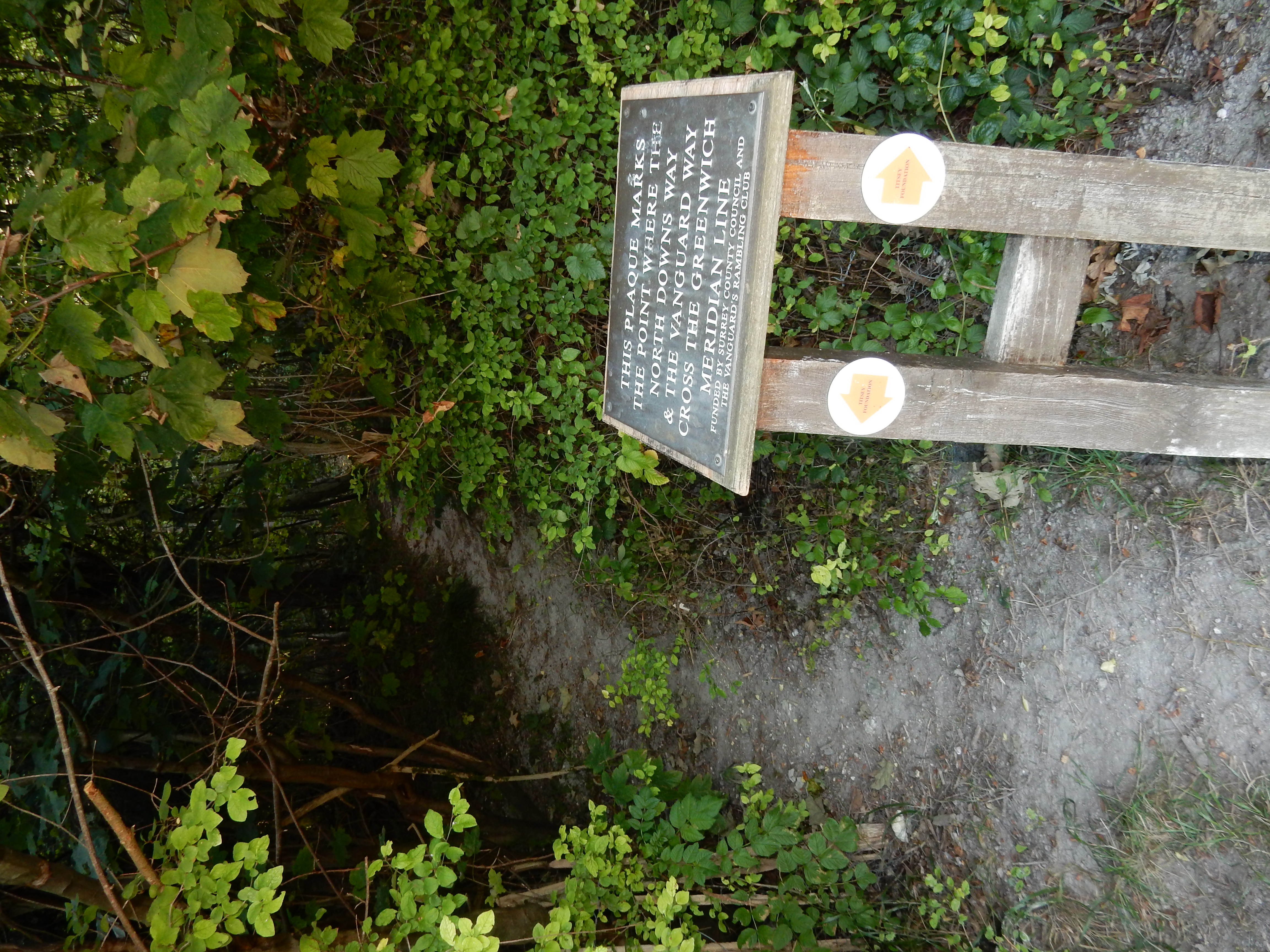
Cross the A233 leading north from Westerham, start an ascent of The Avenue, straddling the Surrey/Kent border, and you notice an abrupt change in the character of the NDW. The next 1½ miles is mainly BLA or actual tarmac; churned up to varying degrees by the the SUVs using it. After the B2024 (Clarks Lane) normal proceedings resume, or might do if new water mains weren't being laid. A little further along the Lane is another example of North Downs Way public art: Coccolith. The theme of this one is the type of fossil mainly responsible for the formation of the Downs during the Late Cretaceous era: the carbon capture event of our dreams. Shortly after coccolith, you enter 3000 acres of woodland around Titsey. Botley Hill, the highest point on this walk, is at the northern edge of these grounds. Visitors receive a caution that some of Titsey's paths are steep. This is no overstatement. In the wet, you might prefer to avoid this DAB on an epic scale or, at least, Pitchfont Lane. During icy weather, I wouldn't go near.
Even in clement conditions there are navigation issues on this final section of the walk. True, some trouble has been taken to supply a precise value for your longitude. However, it's time to leave the NDW and find a way over the M25[10] and down into Oxted. The OS chooses the RT off Pitchfont Lane and uses a footbridge over the motorway. Having gone across that, the OS then follows a fictitious footpath that bears off to the right and cuts across fields before emerging into Silkham Road. Most likely, there was never so definite a route. Today, you find only refuse, overgrowth and barbed wire. After a fruitless search of fifteen minutes, I select Plan B: follow what is marked on Landranger maps as The Greensand Way. This emerges in Park Road, from whence you have suburbia the remaining way to Station Road.