

Parametric data
- Route name:
- CastleAcre
- Start point:
- Castle Acre.
- End point:
- Sedgeford.
- Synopsis:
- A medium distance route along a Roman Road, offering little variety of walking surfaces or scenery, but dead easy navigation 🧭
- This route on OS maps:
- https://explore.osmaps.com/route/27031922/ ...
- OS Explorer sheet ref(s):
- 236 and 250.
- Distance:
- 14.0 miles walked, 13.6 miles flown.
- :
- 5.3 hours.[1]
- Ascent:
- 190 metres.
- Stiles:
- 0 (zero).
- Landmark of note:
- The trail art near Little Massingham.
- Feasible excursion:
- For provisions to the shop in Great Massingham.
- Waypoints:
- Massingham Heath, Great Massingham, Harpley Dams, Fring.
- Fuel:
- Packed lunch taken at the Norfolk Songline Stone. Check the wind direction before tackling a bacon sandwich 🥪
- :
-
 21°C,[2] ⛅️
Would have been pleasant if I wasn't short of water.
21°C,[2] ⛅️
Would have been pleasant if I wasn't short of water.
-
Free of in-road walking: -
 The Massingham Road has about a mile without footway. Not
scary.
The Massingham Road has about a mile without footway. Not
scary.
-
Footpath construction: -
 You walk a bit of everything here.
-
Footpath condition: -
 Nearing the end of a long drought. Everything very dry.
-
Vistas: -
 Norfolk is not the county for these.
Blackberries:-
The drought has done them no favours.[3]
Route map.
Walk notes.
How did the Devil come? When first attack?
These Norfolk lanes recall lost innocence,
The years fall off and find me walking back
Dragging a stick along the wooden fence
Down this same path, where, forty years ago,
My father strolled behind me, calm and slow.
John Betjeman.
A Few Late Chrysanthemums (1954)
Leaving Castle Acre, I pass the convenience store shown above. It would have been a good idea to have purchased extra water because no further opportunity occurs on the whole walk - unless you are prepared to detour into Great Massingham, which has a pub and a small store by the church.[4] There are also the West Acre Gardens, but they are 1½ miles off route. Cloud cover today is only partial, and it doesn't take long for the temperature to exceed the mid twenties.
For the first three miles I face a gentle, mainly uphill gradient along the Massingham Road. Until Old Wicken Cottages the Peddars Way (strictly) runs along the fields on the western side of the road. As traffic is so light today, I prefer the easier going along tarmac. With no bends to hide them, approaching vehicles can be seen and heard from far off. The downside is that what does come is moving rather fast.

At the heath, the road turns northwards into Great Massingham while you continue straight on along an unmade track. Arriving at this junction, it is not immediately apparent that you have just conquered one of Norfolk's highest peaks. Yet confirmation that the dizzy height of 92 metres ASL has been attained is supplied by a an OS triangulation pillar. It stands on the wonk - as though about to collapse through oxygen starvation at this altitude. What little you do have to breathe over the next ½ mile has a distinctive ... bouquet. This is due to nearby pig farming, which the North Folk have expanded considerably over recent years.[5] Perhaps they became bored with turkey for the main course. Obtain dessert from the upcoming Rhubarb Cottage.
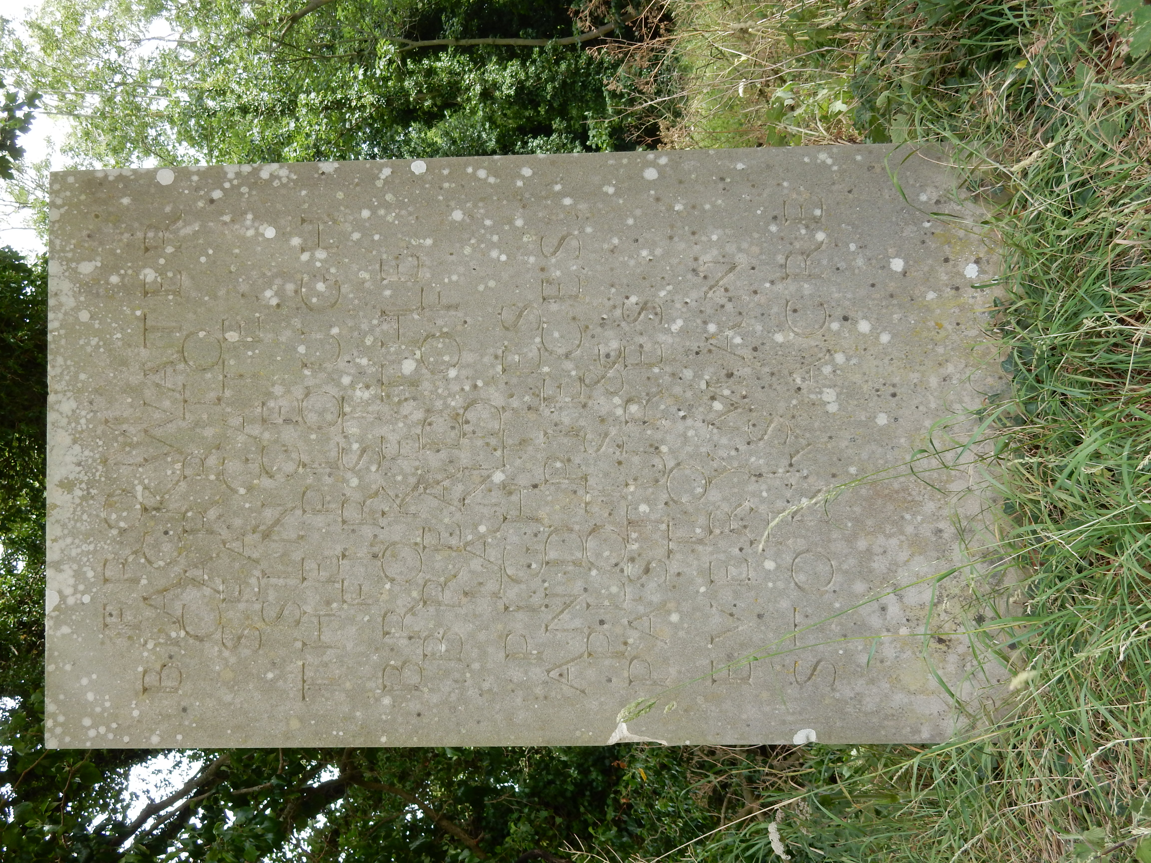
No turkey or pig is depicted on the trail art for this section where it passes Little Massingham. It isn't John Betjeman, either. What is now called Little Massingham Pig Farm was, claims the OS, once Clarke's Farm. Oink.[6]
At Harpley Common there is an info board with brief details about the round barrows you observe from the Peddar's. As you approach the main road, traces can be seen of a dismtd rly. This one is the Midland and Great Northern Joint Railway, which bit the dust in 1959. A short section at the eastern end of it still runs as a heritage line. I hear these locos puffing past my billet in Sheringham.[7] The ghost of John Betjeman lifts his hat as each goes by.
Of the remainder of this walk there is little worthy of note. I encounter a larger number of other walkers than is usual on one of my jaunts. If I begin crawling along on all fours, croaking "Water, water!" then might one of them oblige, I wonder? I choose as an end point for this section the small lay-by on the Fring Road where it is crossed by the Peddar's. I fancy it easy enough to find, but the taxi driver (from Fakenham) has to be introduced to What Three Words before the penny drops for him. It is quite Normal for Norfolk to be happier with pig farms than trending tech.